Severe Weather Alert (April 28-30): Tornado Outbreak and Damaging Storms Threaten Central U.S.
 Severe Weather Across the U.S: Tornadoes, Fires, And Dozen Deaths Severe Weather Across the U.S: Tornadoes, Fires, And Dozen Deaths |
 2025 US Storm Season: Is This Just the Beginning? What to Expect After Kansas and Mississippi Tragedies 2025 US Storm Season: Is This Just the Beginning? What to Expect After Kansas and Mississippi Tragedies |
Severe Weather Emergency
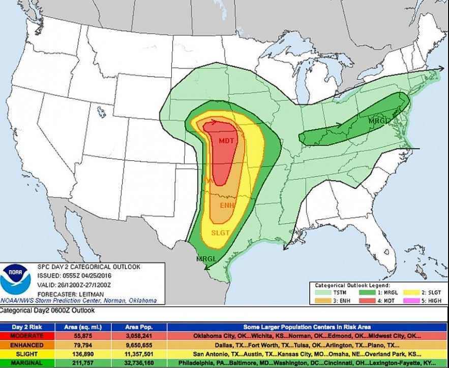
An exceptionally dangerous and widespread severe weather event is unfolding across the central United States between Monday, April 28, and Wednesday, April 30, 2025.
The National Weather Service (NWS) and Storm Prediction Center (SPC) have issued high-level alerts forecasting violent tornadoes, giant hail, hurricane-force winds, and life-threatening flash floods. This multi-day outbreak has the potential to cause widespread destruction and major disruptions to communities in its path.
Meteorologists stress that the atmospheric conditions are "primed" for a severe weather outbreak of historic proportions, particularly in the afternoon and evening hours each day.
Trusted Resources for Updates• National Weather Service - Current Alerts: www.weather.gov • Storm Prediction Center - Updated Outlooks: www.spc.noaa.gov • AccuWeather Severe Weather Live Coverage: www.accuweather.com • Weather.com Live Radar and Forecasts: www.weather.com |
 |
| Major Tornado Outbreak, Catastrophic Hail, and Damaging Winds Threaten Central U.S. |
Tornado Threat (April 28, 2025)
Critical Tornado Threat Areas
Today's greatest threat zones include southern Minnesota, northern Iowa, and western Wisconsin. An intense low-pressure system and warm front are fueling explosive thunderstorm development.
High-Risk Cities
-
Minneapolis, MN: Tornadoes likely; evacuation plans recommended for mobile home residents.
-
Des Moines, IA: High probability of long-track tornadoes; watch for multiple rounds of storms.
-
Kansas City, MO: Severe weather threat peaking late evening; damaging winds a major hazard.
-
Omaha, NE: Increased likelihood of nighttime tornadoes; dangerous after-dark storms.
Tornado Strength and Characteristics
-
EF2 to EF4 intensity
-
Potential for tornadoes exceeding 1 mile in width
-
Storms moving at speeds up to 50-60 mph
Authorities strongly urge all residents to prepare emergency shelters and stay tuned to real-time warnings.
Large Hail and Hurricane-Force Winds
Hail Threat
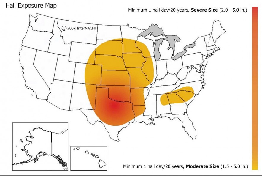
This outbreak is expected to produce exceptionally large hail, some stones reaching 4 inches in diameter.
Impact Risks:
-
Major damage to rooftops, vehicles, windows
-
Significant crop losses expected in agricultural zones
Wind Threat
Forecast models show wind gusts between 80-90 mph, strong enough to:
-
Snap large tree trunks
-
Destroy outbuildings
-
Disrupt air and ground travel across large regions
Preparations should include securing outdoor items, reinforcing windows, and identifying safe rooms.
 |
| A severe weather outbreak |
Flash Flood Emergency Risk
Heavy Rainfall and Flooding Areas
With repeated rounds of thunderstorms, rainfall totals of 2-6 inches are likely in:
-
Des Moines River Valley
-
Mississippi River tributaries
-
Urban zones like Kansas City, St. Louis, and Indianapolis
Flash Flood Watches and localized Flood Warnings are likely to expand.
Safety Reminder: Never attempt to drive through flooded roadways. Water depth can be deceptive, and only a few inches of moving water can sweep a vehicle away.
3-Day Severe Weather Timeline
Monday, April 28
-
Tornadoes, large hail, and damaging winds will explode across Minnesota, Iowa, Nebraska, Kansas, and Missouri.
-
Overnight storms increase risks for communities without early warning systems.
Tuesday, April 29
-
Severe weather shifts toward the Great Lakes, Ohio Valley, and southern Plains.
-
High-impact zones: Dallas-Fort Worth (TX), St. Louis (MO), Indianapolis (IN), Cincinnati (OH), Pittsburgh (PA).
-
Additional flooding possible from heavy downpours.
Wednesday, April 30
-
Severe weather risk continues in parts of the Northeast and Southeast.
-
Primary threats: damaging winds, localized tornadoes, heavy rain.
-
Target cities: Pittsburgh, Cleveland, Buffalo, Nashville, Memphis.
Meteorological Factors Behind the Outbreak
Why This Event Is So Dangerous
-
Strong Cold Front: Forcing warm, moist Gulf air to rise rapidly.
-
Dryline Formation: Separating dry desert air from humid Gulf air, intensifying storm development in Texas and Oklahoma.
-
Jet Stream Alignment: Enhancing wind shear necessary for tornado development.
-
Elevated CAPE (Convective Available Potential Energy): Levels over 3000-4000 J/kg, creating explosive thunderstorm potential.
Preparedness Tips
How to Stay Safe
-
Stay informed: Use NOAA Weather Radios, emergency alert apps, and follow trusted meteorologists on social media.
-
Know your safe place: Interior rooms without windows on the lowest floor of your home.
-
Create an emergency kit: Include non-perishable food, water, medications, first-aid supplies, portable chargers, and a flashlight.
-
Family communication plan: Ensure every family member knows where to meet if separated.
-
Protect your property: Move vehicles into garages or under cover; secure outdoor furniture.
Final Warning
This is not a typical spring storm system. This outbreak could rival some of the most destructive weather events in recent history. Residents across the Central and Eastern U.S. must stay vigilant, act quickly when warnings are issued, and have multiple backup plans ready.
Preparation today could mean survival tomorrow. Stay alert. Stay prepared. Stay alive.
 Winter Storm Warning in Effect for Much of Minnesota: 7 Inches of Snow Possible Winter Storm Warning in Effect for Much of Minnesota: 7 Inches of Snow Possible The National Weather Service (NWS) has issued a Winter Storm Warning for central and northern Minnesota, including areas such as St. Cloud, Minneapolis, and the ... |
 Top 10 Useful Apps to Forecast U.S. Weather in 2025 Top 10 Useful Apps to Forecast U.S. Weather in 2025 From the wide range of weather apps available, we have selected ten of the best for Android and iOS smartphones in the US. These are ... |
 Monster March Storm Unleashes Tornadoes, Snow, and Destruction Across the U.S. Monster March Storm Unleashes Tornadoes, Snow, and Destruction Across the U.S. A powerful storm system, referred to as the "Monster March Storm," is currently sweeping across the United States, bringing a combination of severe weather events, ... |


