Severe Storms and Tornadoes Threaten South-Central, Northeast, and Southeast U.S.
Severe Weather Alerts Issued for Millions Across the U.S.
A dangerous multi-day severe weather outbreak is unfolding across large portions of the United States, threatening millions from Texas to the Gulf Coast, and New York to Florida. The National Weather Service (NWS) and NOAA Storm Prediction Center (SPC) have issued tornado watches, severe thunderstorm warnings, and flash flood alerts as of Tuesday morning.
Quick Overview:
-
Tornadoes possible: Especially in eastern Texas and western Louisiana
-
Flood risk: Significant across the Mississippi Valley and Gulf states
-
Damaging winds and hail: Expected across central U.S. into the Northeast
-
Travel disruptions: Likely at major airports in Houston, Atlanta, New York, and Miami
 |
| Severe Weather Could Pack Tornadoes |
South-Central U.S.: Tornado Risk and Flooding Emergency
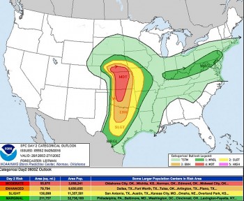
The highest threat level today is across eastern Texas, western Louisiana, and southern Mississippi, where a Level 4 out of 5 severe weather risk is active.
Tornado Watches in Effect:
-
Central and southeast Texas (including Houston, Austin, College Station): until 4 p.m. CDT
-
Eastern Texas and western Louisiana (including Shreveport, Lake Charles): until 9 p.m. CDT
Meteorologists are warning of long-track tornadoes, potentially EF2+ intensity, especially within the red-shaded risk zones. Supercell thunderstorms capable of large hail (up to 2.5 inches in diameter) and wind gusts up to 80 mph are forming along a warm front draped from central Texas into western Louisiana.
Flash Flood Alerts:
-
Rainfall totals of 6–10 inches, locally higher, are forecast from Houston to Baton Rouge
-
Cities like New Orleans, Biloxi, and Jackson, MS are at high risk of flash flooding due to training thunderstorms
-
Urban and low-lying areas are especially vulnerable
Coastal Alerts:
-
Gale Warnings and Small Craft Advisories in effect for Galveston Bay and coastal Louisiana
-
Dangerous rip currents expected along the Gulf Coast
Northeast U.S.: Flooding Threat as Storms Intensify
The Mid-Atlantic and Northeast face localized severe storms and flash flooding through Tuesday night and into Wednesday.
Areas Under Flood Watch:
-
New York City, Philadelphia, Trenton, Scranton
-
Eastern Pennsylvania, New Jersey, and southern New England
A stalled low-pressure system combined with Atlantic moisture is causing persistent downpours. Flash flooding is most likely where rainfall totals exceed 2 to 4 inches in a short time, particularly in urban areas and near creeks and rivers.
Impacted Rivers:
-
Esopus Creek, Housatonic River, and Passaic River could reach minor to moderate flood stage
-
Flooding may lead to road closures, basement flooding, and transit disruptions in cities and suburbs
Southeast U.S. & Florida: Daily Storms with Isolated Severe Threats
The Florida Peninsula, as well as parts of southern Alabama and Georgia, are experiencing a surge of tropical moisture that will trigger daily rounds of thunderstorms through midweek.
Storm Hazards:
-
Localized hail, gusty winds up to 60 mph
-
Torrential downpours may cause street flooding in urban areas like Tampa, Orlando, Miami
-
Flight delays likely at Miami International, Orlando International, and Tampa International Airport
Even non-severe storms could lead to air traffic control ground stops, especially during peak travel hours.
Forecast Through Midweek
| Region | Primary Threats | Peak Timing | Cities Most At Risk |
|---|---|---|---|
| South-Central U.S. | Tornadoes, flash floods, hail | Tuesday afternoon – night | Houston, Austin, Shreveport, Baton Rouge |
| Northeast U.S. | Flash floods, isolated tornadoes | Tuesday evening – Wednesday | NYC, Philadelphia, Albany, Trenton |
| Southeast/Florida | Heavy rain, gusty winds, air travel delays | Daily, esp. afternoons | Miami, Orlando, Mobile, Pensacola |
Safety Recommendations
“Turn around, don’t drown” — NWS reminder on flood safety.
-
Stay informed: Use NOAA Weather Radio or mobile alerts
-
Prepare for outages: Charge electronics, keep flashlights and food stocked
-
Avoid driving through water: Just 6 inches of moving water can sweep a car away
-
Secure outdoor items: Patio furniture, grills, trash bins should be anchored or stored
-
Review tornado shelter plans: Identify interior rooms or storm shelters
How to Stay Updated
Follow real-time updates from:
-
Local emergency management alerts
 Amazing Facts About Thunderstorms: Causes, Types and How to Stay Safe Amazing Facts About Thunderstorms: Causes, Types and How to Stay Safe Whether you enjoy stormy weather or not, thunderstorms happen anyway. But how much do you really know about thunderstorms? |
 Winter Storms Expected to Impact Thanksgiving Travel in 2024: Key Details and Preparations Winter Storms Expected to Impact Thanksgiving Travel in 2024: Key Details and Preparations This Thanksgiving season, a significant winter storm system is forecast to affect millions of travelers across the U.S |
 Severe Weather Forecast (April 28-30): Tornado Outbreak and Damaging Storms Threaten Central U.S. Severe Weather Forecast (April 28-30): Tornado Outbreak and Damaging Storms Threaten Central U.S. Severe tornado outbreak, large hail, damaging winds, and flash floods are threatening the Central U.S. from April 28-30, 2025. Stay updated with critical forecasts, safety ... |
 Severe Storms Strike Pittsburgh: Tornado Warnings, 70+ MPH Winds, Power Outages Severe Storms Strike Pittsburgh: Tornado Warnings, 70+ MPH Winds, Power Outages Severe storms battered the Pittsburgh area on April 29, 2025, bringing tornado warnings, destructive winds over 70 mph, widespread power outages, and significant damage across ... |
 Severe Thunderstorm Warnings Issued Across U.S as Dangerous Storm System Moves Through (May 3–5, 2025) Severe Thunderstorm Warnings Issued Across U.S as Dangerous Storm System Moves Through (May 3–5, 2025) Severe thunderstorms hit the Northeast and Mid-Atlantic U.S. with damaging winds, hail, and heavy rain from May 3–5, 2025, triggering widespread weather warnings and power ... |