Severe Thunderstorm Warnings Issued Across U.S as Dangerous Storm System Moves Through (May 3–5, 2025)
 Severe Weather Forecast (April 28-30): Tornado Outbreak and Damaging Storms Threaten Central U.S. Severe Weather Forecast (April 28-30): Tornado Outbreak and Damaging Storms Threaten Central U.S. |
 Severe Storms Strike Pittsburgh: Tornado Warnings, 70+ MPH Winds, Power Outages Severe Storms Strike Pittsburgh: Tornado Warnings, 70+ MPH Winds, Power Outages |
Overview: Widespread Severe Weather Hits Northeast and Mid-Atlantic
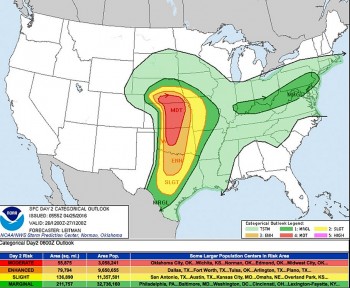
The National Weather Service (NWS) has issued multiple severe thunderstorm warnings and watches across the northeastern and mid-Atlantic United States, including New England, New York, and the Washington, D.C. area, as a strong frontal system moves eastward this weekend.
Residents are urged to stay alert through Sunday, May 5, with damaging winds, large hail, heavy rain, lightning, and isolated tornadoes all possible.
 |
| Severe thunderstorm warnings |
Key Impacts by Region (May 3–5, 2025)
New England: Violent Storms Sweep Across Saturday Evening
-
Severe Thunderstorm Warnings were active from the afternoon through 10 p.m. on Saturday, May 3, in:
-
Massachusetts (including Boston)
-
New Hampshire
-
Maine
-
Connecticut
-
-
Storm timeline:
-
2–6 p.m.: Southern Vermont, western Massachusetts, and New Hampshire saw initial storm development.
-
6–8 p.m.: Storms moved into Greater Boston, bringing vivid lightning, torrential rain, and gusts up to 70 mph.
-
8–10 p.m.: Storms weakened while reaching Cape Cod and southeastern Massachusetts.
-
-
Impacts:
-
Power outages affected over 8,000 homes in Connecticut alone.
-
Wind damage reported in Springfield, MA, with downed trees and power lines.
-
Localized flooding occurred in low-lying areas around Worcester and Manchester.
-
Washington, D.C. & Mid-Atlantic: Thunderstorm Watches Extend Into Sunday
A Severe Thunderstorm Watch remains in effect until 10 p.m. Saturday for the following Virginia, Maryland, and D.C. areas:
-
Virginia: Fauquier, Prince William, Stafford, Arlington, Fairfax, and the cities of Alexandria and Manassas
-
Maryland: Frederick, Montgomery, Prince George's, Anne Arundel, and Carroll Counties
-
District of Columbia
Severe Thunderstorm Warnings were issued for Frederick County (until 5:45 p.m.) and Prince William and Fauquier Counties (until 6 p.m.).
-
Threats:
-
Damaging wind gusts up to 60 mph
-
Hail up to 1 inch in diameter
-
Frequent cloud-to-ground lightning
-
Brief tornado potential in western Virginia and Maryland foothills
-
-
Storms are forecast to linger overnight into Sunday morning, with flooding concerns in urban areas such as D.C. proper and inner beltway suburbs.
Southern California: Light Rain, Cooler Temperatures, and Mountain Snow Possible
While the East Coast faces severe thunderstorms, Southern California braces for a cool, wet weekend as a low-pressure system pushes inland.
Forecast Summary (May 3–5, 2025):
-
Saturday Night into Sunday Morning:
-
Rain expected across Los Angeles, Orange County, Inland Empire, and valleys
-
Totals of 0.10 to 0.25 inches
-
Drizzle in the morning, followed by evening showers
-
Mountain snow possible above 6,500 feet and isolated thunderstorms in higher elevations
-
-
Temperatures:
-
L.A. & Orange County: Highs near 67°F, lows around 56°F
-
Beaches: Cooler, with highs of 63°F, lows around 54°F
-
Mountains: Highs near 61°F Saturday, dropping to the mid-40s Sunday
-
Deserts: Gusty winds and a slight rain chance Sunday, with highs around 75°F
-
-
Extended Outlook:
-
Below-average temperatures linger through Monday
-
Gradual warming trend starts Tuesday, May 6
-
Forecast Breakdown: Sunday, May 4 – Monday, May 5
Sunday, May 4:
-
New England:
-
Temperatures in the 60s, dropping into the 50s in coastal Massachusetts due to a northeast sea breeze.
-
Scattered showers throughout the day, increasing in intensity after 4 p.m.
-
Fog and humidity will persist overnight.
-
-
Mid-Atlantic:
-
Residual thunderstorms in early morning.
-
Showers tapering off by midday, with mostly cloudy skies and highs in the upper 60s.
-
Monday, May 5:
-
A cutoff low-pressure system settles over the eastern U.S., bringing prolonged rainfall and cooler temps:
-
New England & Mid-Atlantic: Highs only in the mid-50s to low 60s
-
Heavy rain bands possible across New Jersey, Pennsylvania, and New York
-
Flash flood watch may be issued depending on rainfall totals
-
Severe Weather Preparedness Tips
Residents in all affected areas should:
-
Monitor NWS alerts via weather.gov or NOAA weather radio.
-
Seek shelter immediately if a warning is issued—don’t wait for lightning or visible storms.
-
Avoid flooded roads; turn around, don’t drown.
-
Charge devices, gather flashlights, and secure loose outdoor items.
-
Keep emergency kits stocked with water, non-perishable food, and first aid.
Looking Ahead: Midweek Relief, Weekend Threat Returns
-
Tuesday, May 6 – Wednesday, May 7: Continued cool, unsettled weather with off-and-on showers. Slight improvement by Wednesday afternoon.
-
Thursday, May 8: Likely the driest day of the week with sun peeking through and highs near 70°F.
-
Friday, May 9: Another weak system may bring scattered showers, particularly in the Northeast.
-
Mother’s Day Weekend (May 10–11):
-
Saturday: Another storm system approaches, raising severe weather risks again.
-
Sunday: Forecasts call for sunny skies and comfortable highs in the mid to upper 60s, making for a pleasant Mother’s Day—at least for now.
-
 Amazing Facts About Thunderstorms: Causes, Types and How to Stay Safe Amazing Facts About Thunderstorms: Causes, Types and How to Stay Safe Whether you enjoy stormy weather or not, thunderstorms happen anyway. But how much do you really know about thunderstorms? |
 Winter Storms Expected to Impact Thanksgiving Travel in 2024: Key Details and Preparations Winter Storms Expected to Impact Thanksgiving Travel in 2024: Key Details and Preparations This Thanksgiving season, a significant winter storm system is forecast to affect millions of travelers across the U.S |