Winter Storm Updates: Dangerous Ice in the South, Heavy Snow in the Northeast, and Multi-Day Travel Disruptions
Summary of Winter Storm Updates
-
Historic reach: more than 240 million people across 40+ states in the storm’s path.
-
Record snows and ice: including Little Rock’s snowfall record and extensive ice corridors.
-
Storm complexity: secondary severe weather threats in the Deep South.
-
Power grid stress: Midwest energy officials asking for conservation.
-
Travel chaos: widespread cancellations and highway hazards.
 |
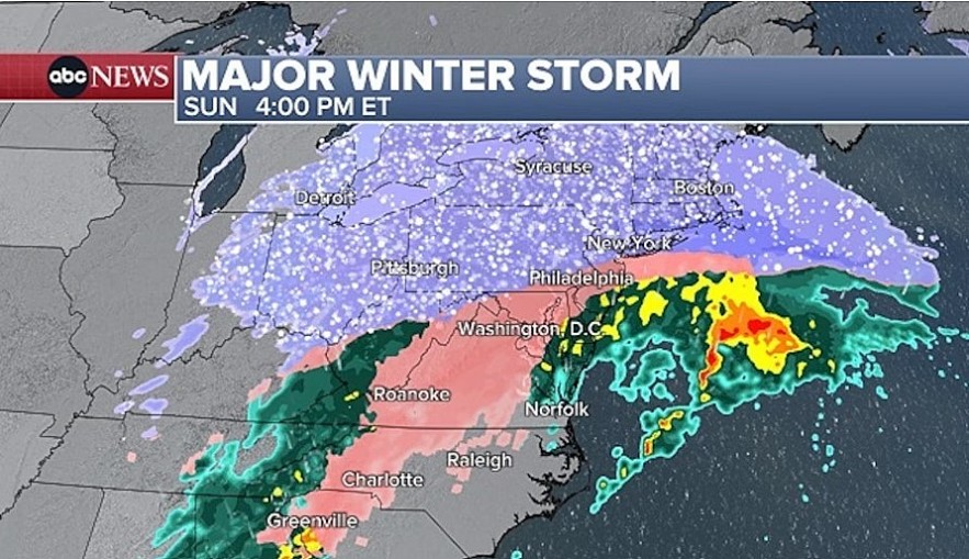
| Winter storm live updates: At least 18 states declare state of emergency. Source: ABC News |
A sprawling, high-impact winter storm - Winter Storm Fern - is driving dangerous conditions across a huge stretch of the U.S., with forecasters warning that ice, heavy snow, and bitter cold will keep travel and daily life disrupted into early next week. ABC News reported that at least 18 states have declared emergencies as the storm expands, and impacts are broadening from the South into the Mid-Atlantic and Northeast.
Air travel is taking a major hit. Media’s live updates show thousands of cancellations building as the storm moves into major hub regions. Other reporting based on FlightAware data shows cancellations climbing dramatically through Monday, with major hubs such as Dallas–Fort Worth and other large airports among the hardest-hit.
What’s happening now and what’s next
The key hazard in the South is ice (freezing rain/sleet), which can down trees and power lines and create dangerous roads. The key hazard in the Northeast is heavy snow plus strong winds and persistent cold that can keep roads slick and slow recovery.
A NOAA update also warned this is an unusually large, severe system with dangerously cold air lingering behind it across a large portion of the country.
Severe Weather Threat in Unexpected Areas
While most attention has focused on snow and ice, meteorologists from Fox Weather warn that parts of the Gulf Coast and Deep South are at risk of a secondary severe weather threat, including thunderstorms with wind gusts exceeding 60 mph and even a low-end tornado risk — an unusual and dangerous twist accompanying this winter system.
Grid Stress and Energy Demand Rising
The storm’s impact on the energy system is also mounting. A Midwest power grid operator has publicly urged residents to conserve electricity as demand surges amid the extreme cold and widespread heating needs, highlighting the strain on infrastructure that can accompany multi-day winter events.
Hard Numbers: Snow, Ice, Outages, and Disruptions
Here’s the latest snapshot of critical winter-storm metrics across the U.S.:
-
Population under alerts: 240+ million — one of the largest winter storm impacts in recorded U.S. history.
-
States under emergency declarations: At least 18–21 states and Washington, D.C. — including southern, Mid-Atlantic, and Northeastern states.
-
Flight cancellations: Tens of thousands canceled nationwide as Fern grounds major hubs and spreads disruption over a multi-day period.
-
Power outages: Over 135,000 customers reported without power as of Sunday afternoon, with ice-laden trees and lines to blame.
-
Historic records: Snow amounts and ice accumulation have already set local records in spots such as Little Rock.
Regional impacts at a glance
| Region | Primary threat | What to expect | Timing (rough) |
|---|---|---|---|
| Southern Plains (TX/OK/AR) | Ice + dangerous roads | Sleet/freezing rain; outages possible; bridges/overpasses worst | Ongoing into weekend |
| Southeast (GA/Carolinas) | Damaging ice | Higher risk of downed trees/power lines; prolonged outages possible | Weekend peak |
| Ohio & Tennessee Valleys | Snow + ice + cold | Mixed precip; hazardous travel; refreeze overnight | Weekend into Monday |
| Mid-Atlantic (DC/MD/VA) | Heavy snow + some mixing | Snow totals can disrupt commutes; lingering impacts Monday | Late weekend–Monday |
| Northeast (NYC/Philly/Boston) | Heavy snow + wind | Periods of heavy snow; major travel disruptions; cold prolongs impacts | Sunday–Monday |
NYC spotlight: snow alert, warnings, and schools
In the New York City area, official messaging is increasingly specific. The NYC Department of Sanitation issued a Snow Alert for Sunday, Jan. 25, starting 1 a.m., citing forecast guidance converging around roughly 9–12 inches for much of the city (with local variation).
The National Weather Service office serving the NYC region also issued updated winter messaging and briefing materials warning of major travel impacts Sunday into Sunday night, with impacts potentially lingering into Monday commutes.
And for parents, NYC made news of its own: multiple outlets report that Mayor Zohran Mamdani said there will be no traditional snow day Monday—schools will either be in-person or remote, with a decision on building status expected by noon Sunday.
NYC quick reference
| NYC item | Latest official-style takeaway |
|---|---|
| Snow operations | DSNY Snow Alert begins 1 a.m. Sunday; plows/salt crews mobilized |
| Forecast uncertainty | NWS notes small timing shifts can change snow/sleet totals and impacts |
| Monday school plan | No snow day; in-person or remote, depending on building closure decision |
Air travel: cancellations are surging
Airlines are cutting schedules as Fern targets major hubs. Reuters reported Delta expanding cancellations in Atlanta and key East Coast airports as the storm threat grew. Flight tracking tallies reported by MarketWatch show cancellations stacking into the tens of thousands across the Fri–Mon window, reflecting how broad the disruption has become.
| Day (U.S.) | What travelers are seeing |
|---|---|
| Friday–Saturday | Major cancellations start building, especially in storm-affected hubs |
| Sunday | Often the worst day in large, coast-to-coast storms (more flights scheduled + peak impacts) |
| Monday | Residual cancellations and delays as aircraft/crews reposition and airports catch up |
Emerging Impacts on Transportation and Safety
Severe winter conditions are leading to multi-vehicle crashes and travel paralysis in several regions. In Missouri, a major pileup on Interstate 44 involved multiple semi-trucks jackknifing due to icy surface conditions, underscoring how treacherous roadways remain even as the storm evolves.
Emergency officials continue to urge no nonessential travel, with the greatest danger coming on major interstates and bridges where freezing rain has been most intense.
Power outages: ice is the driver
Reuters reported the storm producing more than 100,000 power outages along with widespread flight cancellations. Electric co-ops and utilities in hard-hit areas have emphasized restoration efforts as ice and wind complicate repairs.
What Residents Should Do Next
Weather services and emergency management agencies reiterate these key steps:
-
Avoid all nonessential travel until roads are cleared and temperatures moderate.
-
Prepare for extended power outages, especially in areas with ice and tree cover.
-
Monitor local alerts — conditions can change rapidly as the storm moves east.
-
Check supplies if you live in rural or isolated areas where services may be delayed.
FAQs
1) When will conditions improve?
In many places, conditions improve after precipitation ends—but cold air behind the storm can keep roads icy into Monday/Tuesday.
2) Why is ice such a big deal?
Ice adds weight to trees and power lines, increasing the risk of outages and making roads dangerously slick.
3) Should I travel this weekend?
If you can postpone, many officials urge avoiding travel during peak conditions; airline disruptions and road hazards may persist into Monday.
4) What should I watch for in forecasts?
Look for changes in storm track and mixing zones (snow vs sleet/freezing rain). Small timing shifts can change outcomes.
5) NYC: Is there a snow day Monday?
NYC officials say no traditional snow day; it will be in-person or remote, depending on whether buildings close.
6) Where do I get the most reliable updates?
Start with the National Weather Service and local emergency management, then use major providers for hour-by-hour planning.
The bottom line
Winter Storm Fern is producing different dangers in different places—ice-driven outages and road hazards across parts of the South, and heavy snow and major transportation disruption farther north and east. With flight cancellations mounting and cold air prolonging impacts, many communities should plan for disruptions that last beyond the heaviest precipitation.


